- History of the Area: Eureka, UT
- What are Patented Mining Claims?
- Mining and the Environment
- Buy 20 acres and play on 1000's
History of the Area: Eureka, UT
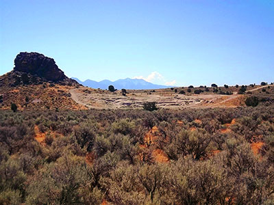
The Patented Mining Claims being offered for sale are located in and around the Tintic Mining District near Eureka, Utah. The Tintic Mining District was officially organized on December 13, 1869. The district was named in honor of the Ute Indian Chief Tintic who lived in the area with his tribe. By 1899, the Tintic District was the leading mining center in Utah; as well as one of 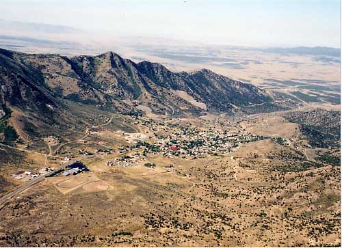 the top producers in the entire United States. To support this mining and exploring activity, numerous towns sprang up and grew. The cities of Mammoth and Silver City were two such towns. In 1910 during the town’s boom, Eureka was the ninth largest city in Utah, with a populaton of around 3,900 people. The mines were producing millions of dollars in profits. Several of the mines were still producing until 1957 when water began to flood the mines making it more and more expensive to retrieve the oar. In 1979, Eureka was placed in the National Register of Historic Places to help protect the town’s historical sites and locations for many years to come.
The Patented Mining claims offered for sale have had no concentrated mining or mineral processing activity conducted on them. However, the process of exploration in the area did result in numeros shafts and holes being dug. Some of the claims being offered have or may have such shafts or holes on them. We have not compiled a detailed location of every hole or shaft. Many of the existing and old maps of the area may show such features. For a more detailed account of mining history in Utah, visit mapstore.utah.gov/Mining/, or click here for an article published in 2006 by the Utah Geological Association titled History, Geology, and Production of the Tintic Mining District, Juab, Utah, and Tooele Counties.

What are Patented Mining Claims?
The properties being offered for sale are old “Patented Mining Claims”. In the mid to late 1800’s as Americans moved west, there were two fundamental ways for them to become owners of property then held only by the American Government – (a) Homesteading and (b) Mining Claims. Most of us have heard and have some understanding of Homesteading. Basically, if you lived and worked on the land for a certain period of time, then so many acres would eventually be given to you in your name. However, this granting of land to the Homesteader sometimes only included the surface. The minerals below the surface were often retained by the Federal Government and later leased or granted to mining or oil and gas companies. The second way for Americans to gain ownership of property was staking a Mining Claim. Similar to Homesteading, where the person seeking the property had to perform certain work or duties to farm the land – in the case of a Mining Claim, the individual had to invest certain time and money to explore for minerals. Upon proving that the Mining Claim in fact contained valuable minerals, a mining claimant became entitled to a Patent, under which the government conveyed full ownership of the claim.
The good news with Mining Claims is that the individual was granted not just the surface, but also the minerals under the ground. Most Mining Claims were never patented. As part of the patenting process, the federal government surveyed the Mining Claim to establish its boundaries and prepared a “Mineral Survey Plat,” reflecting those boundaries. The Plat would detail the claim: its mineral survey number, its location, boundaries with other claims, size in acres and the date/signature of the US Surveyor General. When the Patent for a Mining Claim was issued, it would refer to the Plat for the official legal description for the claim. Most of the Patented Mining Claims offered for sale were issued and patented in the late 1800’s, and early 1900’s. For example, the Patented Mining Claim of the Tintic Paymaster Mining Company called “Silver Bell” was first located on January 1, 1913. This was combined with several other surrounding parcels, which constitutes the “Silver Bell, G.N.C., Mohawk, Promised Land, Minerva, Silver Flat, Silver Flat No. 1, and Minerva Fraction Lodes.” The official “Plat” for Mineral Survey No. 6597 was patented on October 2, 1926 by President Calvin Coolidge. What is being offered for sale is that very same “Silver Bell” Patented Mining Claim, and many others like it. Each Patented Mining Claim is officially of record in the County Recorder’s Office of Utah County, Utah. A Title Insurance Policy will accompany each Patented Mining claim offered for sale. The surface ownership rights will be conveyed to the buyer using a Special Warranty Deed. No mineral or water rights are being sold with these properties. The buyer should understand that the principal value of these Patented Mining Claims is for their historical and recreational value.
Mining and the Environment
Mining activity, even just the digging of shafts and holes, does bring up the matter of environmental concerns. Although it is recognized that the history of the entire Tintic Mining District is mining and mineral processing, the actual existing and identified environmental issues are primarily located in a few specific sites where the ore in the rocks was condensed into metal called smelting. Aside from a few holes and/or shafts dug for exploration, there have been no smelting operations on the specific Patented Mining Claims being offered for sale. Furthermore, the smelting operation sites in the surrounding areas have long been cleaned up. A Phase I Environmental Site Assessment (ESA) was completed on the Patented Mining Claims being offered for sale. In summary, the report states that “no Recognized Environmental Conditions (RECs) currently exist on the Property.” None of this mining activity diminishes the historical or recreational value of the properties. In fact, many feel it enhances its character.
Pinyon Canyon Properties Phase I ESA Part 1 | Part 2 | Part 3 Saddle View Ranches Phase I ESA
Buy 20 acres and play on 1,000’s
 Why do we say, “Buy 20 Acres & Play on 1,000’s?”
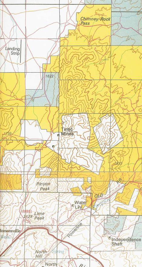
The areas on this map that are “white” are “Private Property.” The areas in “yellow” are “Public Property,” managed by the Bureau of Land Management (BLM). Pinyon Canyon Properties is surrounded by public BLM land.
When you buy one of the Pinyon Canyon Properties, which are about twenty acres each, you can play on thousands of acres of public BLM ground with endless trails and miles of open spaces. Thus, “Buy 20 Acres & Play on 1,000’s.”
Surrounding area hotspots
Eureka, Utah
Chimney Rock and Little Moab
Little Sahara Recreation Area
ATV/UTV Trails
Utah Lake
Vernon Reservoir
The Tintic Mining Museum
Eagle and Bluebell Mine Ruins
Silver City Ghost Town
The Tintic Silver Festival
Simpson Springs
Topaz Mountain
Paul Bunyan’s Woodpile
Baker Hot Springs
Mt. Nebo Scenic Route Byway, Nephi